Currituck County Planning Department
August 2011
Acknowledgements
Earl Wemer
Paul Hanson
Carol Dudek
Gary McGee
Sharon Twiddy
Scott Austin
Edward Ponton
Rick Willis
Dick Brindley
Carole Thompson
Hadley Twiddy
Meghan Agresto
Bill Richardson
Edna Baden
Karen Whitfield
County Staff
Ben Woody
Holly White
Jason Litteral
Brad Schuler
Jennie Newbern
Susan Tanner
Print Corolla Village Small Area Plan
Table of Contents
Introduction
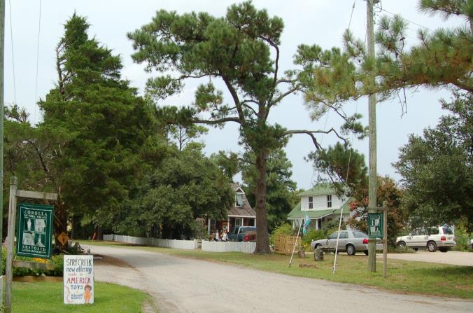
The Corolla Village we know today is very different from that of the past. Corolla Village has evolved and grown dramatically over the past century. However, the imprint of the past is obvious in what remains today. This interplay of past and present is distinct from other Outer Banks Communities.
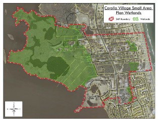
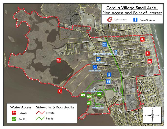
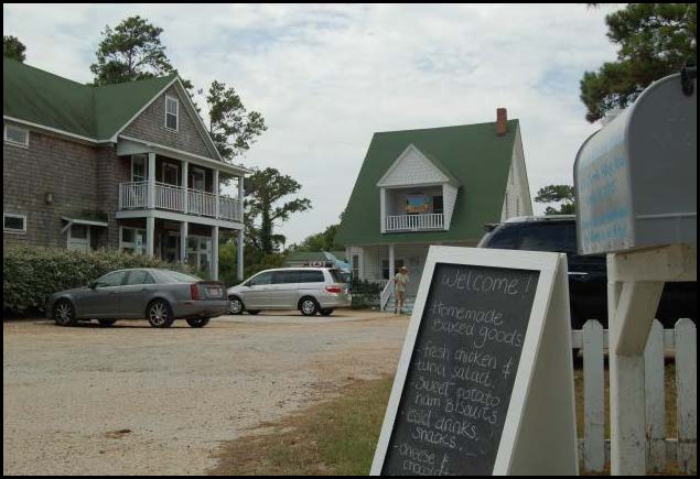
The study area encompasses the Corolla Village Subdivision, portions of Corolla Light Subdivision, the Whalehead Club, and the Currituck Beach Lighthouse. Corolla Village is centrally located on the Currituck Outer Banks and is a hub for cultural, historical, and ecological learning opportunities. There are more destinations in close proximity than in any other area of the Currituck Outer Banks. These destinations include local, state, and federally recognized sites such as the Whalehead Club, Currituck Beach Lighthouse, NC Wildlife Education Center, Corolla Chapel, Corolla Wild Horse Museum, and Corolla Post Office. Corolla Village is a hidden gem reminiscent of the past with unpaved streets, original or renovated structures, and mature live oaks.
The Board of Commissioners recognizes the uniqueness of the Village and as a result requested that growth and development be addressed in a comprehensive manner.
This Small Area Plan (SAP) examines unique issues, concerns, and aspirations of this community and works to establish public policy that will help achieve the vision for the area. The SAP includes policies that will address the environment, land use, economic development, community heritage and sense of place, and transportation. This plan was developed with input from the community and oversight from the Board of Commissioners. Upon adoption, the plan is used to assist staff and the Board of Commissioners in guiding growth as well as planning for future improvements.
The goal of the Corolla Village Small Area Plan is to balance growth in a way that preserves the physical and natural environments that make Corolla Village distinct from other coastal communities. This includes anticipating the impacts of future development, protecting natural resources, preserving the coastal village feel, and maintaining a high quality of life for current and future residents..
Corolla Village
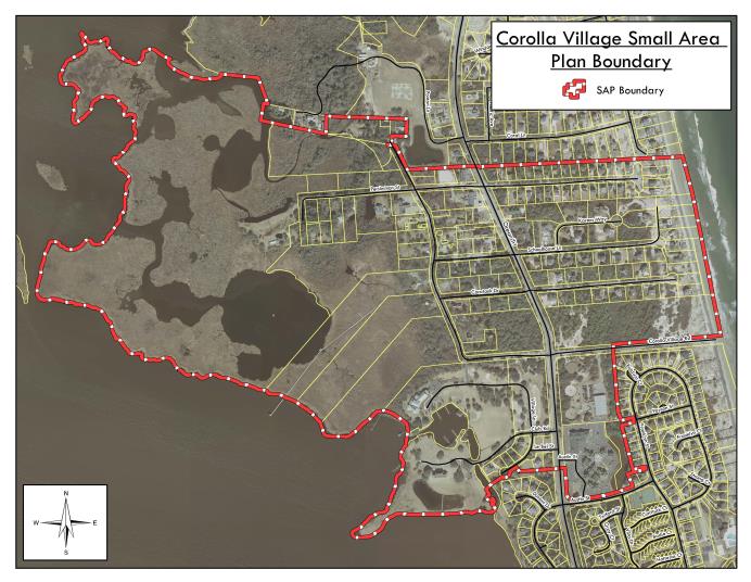
Corolla Village Small Area Plan Boundary
Public Outreach
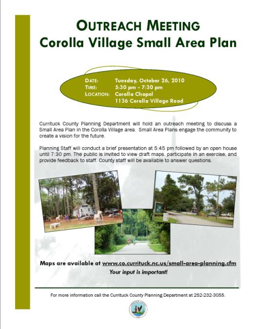
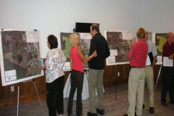
The Corolla Village Small Area Plan process was conducted over the course of a year. During the planning process, citizens as well as business and land owners were invited to provide input through a series of community outreach meetings. The community was asked a series of key questions in an effort to gather information used in drafting policy statements for the plan. These questions and responses included:
- What is unique about Corolla Village?
40% Historic character
29% Outer Banks culture & history
15% Landmarks
10% Diverse small businesses
6% Green space
1% Other - What opportunities exist to enhance Corolla Village?
41% Preserve the uniqueness of the area
23% Pedestrian improvements (i.e. walking, biking, trails, boardwalks)
21% Keep the area natural
7% Restrooms
5% Signage/Way finding
3% Other - What are potential threats to the character of Corolla Village?
34% Big box buildings/chain retail stores
24% Loss of trees and open space
21% Traffic
18% Mid-county bridge
2% Small area plan
1% Other
Vision
During the summer and fall of 2010, the public shared their concerns, hopes, and desires for Corolla Village. Together the residents, business owners, and members of the community discussed their vision of Corolla Village in ten years. The vision statement below is a fusion of these individual ideas.
The community is committed to preserving the unique, coastal village feel and sense of place in Corolla Village by planning for and strategically balancing future development. We strive to maintain and enhance the quality of life by:
- Supporting development concepts that foster and promote desirable characteristics such as compact building style and traditional, coastal architectural features.
- Encouraging sites to be designed at a human scale.
- Protecting water quality and existing tree canopy.
- Encouraging the use of alternative transportation.
- Preserving unique physical and natural resources important to the cultural heritage of the area.
- Promoting the growth of existing businesses and compatible new businesses.
We recognize that with careful planning, Corolla Village will continue to grow as a destination while preserving the physical and natural environments that make it distinct from other coastal communities.
However, we acknowledge that in order to secure this future we must work together, treating all with respect and fairness focusing on common goals and remembering the past.
We desire to continually set and maintain high standards of excellence which exemplify dedication to our goals and to the fulfillment of this vision statement.
Existing Conditions & Analysis
Land Use
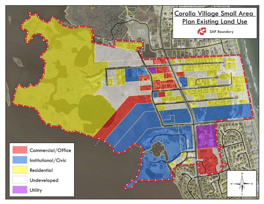
The existing land use pattern within the Corolla Village study area is comprised of clustered residential development interspersed with business and office uses that is heavily anchored on the southern study boundary by civic/institutional uses. The existing land use map shows that the study area is comprised of 292 acres. The largest portion (48%) of the study area is occupied by residential land uses. However, approximately 52% of the residential occupied land contains wetlands. Surprisingly, only 9% or 26 acres of the study area contain commercial or office uses. The majority of the commercial/office development is either focused in the heart of Corolla Village or along Highway 12. In contrast, almost 16% of the study area is considered undeveloped and over half of that area is contained in wetlands.
The study area also includes a significant portion of institutional and civic uses. This area of the Outer Banks is often seen as a hub for cultural, historical, and ecological learning opportunities. The Currituck Lighthouse, Wildlife Education Center, Whalehead Club, Corolla Schoolhouse, Corolla Chapel, County offices, library, post office, and other similar uses make up 25% of the study area. This area will continue to emerge as a community center because of the concentrated civic and institutional opportunities present.
Future development within the study area may prove challenging because of the large acreage of wetlands (132 acres or 40%) present in the study area. This combined with a natural mix of residential
and commercial uses, and a basic framework for pedestrian traffic, will present opportunities for the “marginal development” of wetland areas. Development should be encouraged to occur in a way that is consistent with the future land use map for the study area.
Land Use | Uplands Acreage (%) | Wetlands Acerage (%) | Total Acerage | Area Percentage |
| Commercial/Office | 16 (62%) | 10 (38%) | 26 | 9% |
| Institutional/Civic | 48 (65%) | 26 (35%) | 74 | 25% |
| Residential | 67 (48%) | 72 (52%) | 139 | 48% |
| Undeveloped | 22 (48%) | 24 (52%) | 46 | 16% |
| Utility | 7 (100%) | 0 (0%) | 7 | 3% |
| Total | 160 (54%) | 132 (45%) | 292 | 100% |
Environment
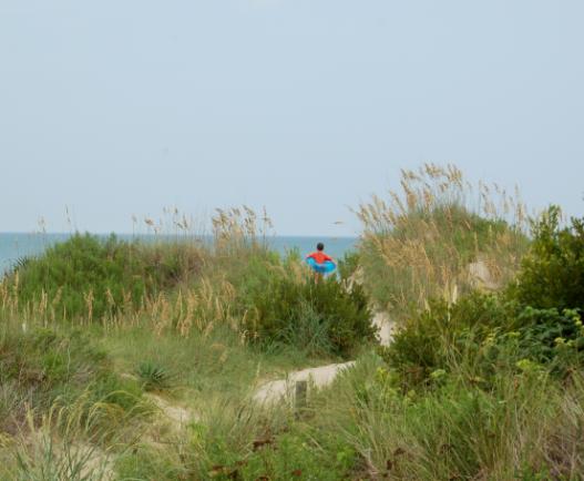
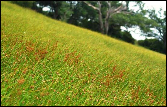
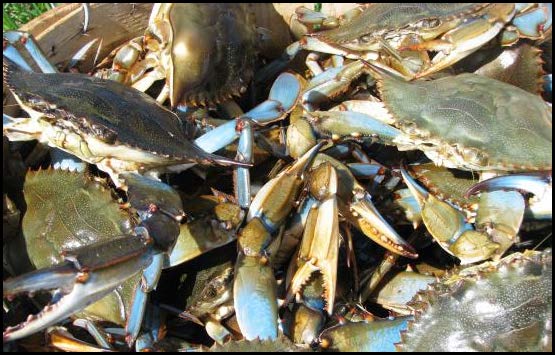
The abundance and variety of natural resources located within the Corolla Village study area make it unusual and rare. Due to the mixing of the warm Gulf Stream Current and the cool Labrador Current off the Currituck Banks, a unique climate is created where northern and southern species overlap. This results in the presence of a diversity of species from both regions. Habitats present in the study area include ocean beach, sand dunes, grasslands, shrub thickets, maritime forest, brackish and freshwater marshes, and tidal flats. In addition, there is an abundant population of commercial and game fish as well as many species of birds.
The entire western portion of the study area is comprised of both fresh water and salt water wetlands. This area makes up over 45 percent of the study area. These wetlands serve as critical habitat for wildlife, nursery area for fish, and a filter for stormwater. Sustaining high water quality is important and directly related to maintaining a suitable environment for tourism, outdoor recreation, and the fishing/crabbing industry.
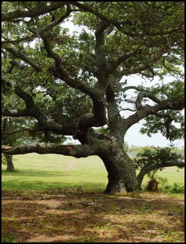
There are also large expanses of maritime forest within the study area. Identification and protection of the maritime forest is important because of their multi pronged role. The live oak, a common species prevalent in maritime forest, frames many of the roads and land in the study area providing shade for pedestrians, protection of structures from high winds during storm events, and natural beauty reflective of a well established, coastal village character.
Sense of Place & Community Heritage
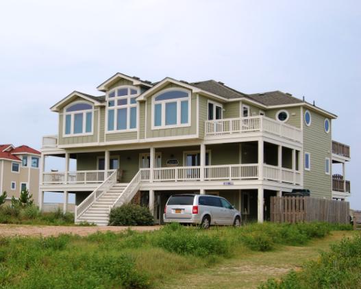
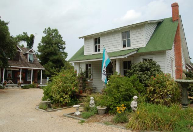
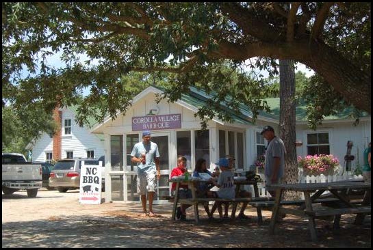
The Corolla Village study area allows visitors and residents to have a glimpse into the past history of the area where large, well established live oaks line unpaved roads and people enjoy iced tea on front porches. This community was established prior to the dense development patterns now present in Corolla. Many of the buildings within the study area reflect architectural features common of the typical Outer Banks style architecture that are worth preserving and encouraging future development to replicate.
The core of the study area is anchored by the Currituck Lighthouse, Whalehead Club, Corolla Schoolhouse, and Corolla Chapel. There are also many other original structures in the village that have been preserved, renovated, and are being utilized as homes, offices, and commercial businesses. In addition to these structures, many County resources such as the library and County offices as well as the Wildlife Education Center are located within the study area. These assets are what set the Corolla Village study area apart from other areas of the Outer Banks making it a hub for cultural, historical, and ecological learning opportunities. As the Corolla Village study area continues to experience growth pressures, careful consideration should be taken to protect the unique sense of place.
Like many other areas of the Outer Banks, much of the heritage of the Corolla Village study area can be directly linked to the environment and abundance of natural resources present. Now instead of hunting, fishing, or crabbing as a means of survival and way of life, many people today enjoy these past times as means of leisure.
The Corolla Village study area has naturally developed on a human scale with buildings clustered together and located closer to the street than present day buildings. The study area also developed with residential and commercial uses co-existing in way that encourages walkability. Efforts should be made to encourage and support future development to occur in a compatible way similar to that of the past that promotes a small village feel.
Transportation
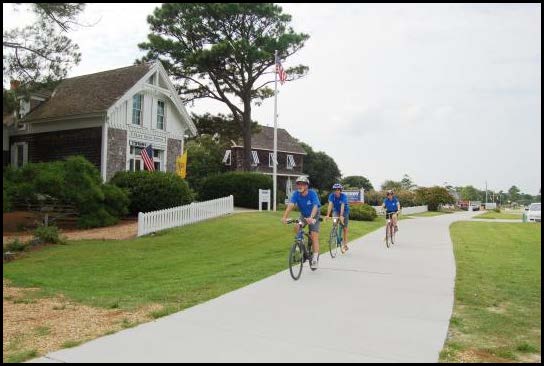
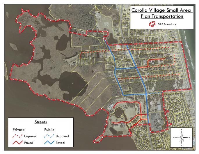
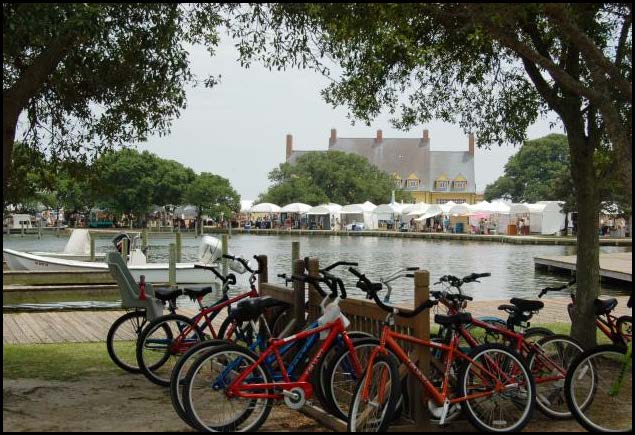
North Carolina Highway 12 intersects the study area and serves as the backbone for transportation improvements. Two other state maintained roads, Corolla Village Road and Schoolhouse Lane, also connect to Highway 12 to create the basic framework for transportation in the study area. Several of the smaller, residential roads in the area still remain unpaved, contributing to the areas uniqueness. In addition to roads, a multi use path extends through the study area parallel to Highway 12, allowing users to safely travel by foot and bike.
During the planning process, pedestrian and vehicular circulation was identified as an area needing improvement. Even though the right of way area is large, the majority of actual pavement in the study area is narrow. This becomes problematic when automobiles, pedestrians, and cyclist are attempting to utilize the roads all at the same time. Many of the businesses in the village center provide minimal vehicle or bike parking, promoting parking along the roadside and further complicating the traffic congestion. A study to examine the causes and develop solutions related to traffic congestion, parking problems, and pedestrian-car conflicts is needed. In addition, continued development of the multi-use path system is encouraged.
Economic Development
Most of the businesses located within the study area are directly related to the tourism industry. Many of these businesses are small scale and locally owned. Services offered in the study area include but are not limited to retail shopping, outdoor tours, photography, food services, property management, and real estate sales. There is only a small portion of land available in the study area that is currently undeveloped. Although there are several large parcels available for development, there is greater potential for redevelopment of existing occupied land.
Participants during the planning process identified the Mid County Bridge project as a potential threat to the study area that could impact the type and intensity of businesses as well as the quality of life. This type of infrastructure improvement could increase the pressure for both increased residential and commercial development. Growth pressures should be balanced in a manner that attracts appropriate economic development opportunities consistent with the vision of the plan. This includes supporting and growing existing small businesses that make Corolla Village unique.
Future opportunities exist to collaborate with local non-profits, other government agencies, and businesses to offer community events that will promote the cultural, historical, archaeological, and natural resources present in the study area.
Implementation
This plan will supplement the Land Use Plan to better address the needs, issues, and uniqueness of the study area over the next ten years. The policies and guidance included in this plan are consistent with the Land Use Plan and other County policies and documents. Upon adoption, this plan will establish a new focus for growth and development. The Small Area Plan is used by the Board of Commissioners and staff to make recommendations about development proposals, use permits, and other County land use policy decisions.
Each year, Planning Staff should facilitate a meeting with other County Departments to assess the completion of actions and provide written documentation to the Board of Commissioners outlining the status. Additionally, the plan should be updated every five years or as needed. All property owners within the study area should be notified of the plan update and invited to provide feedback on any revisions.
Land use decisions should be consistent with the vision, policies, and actions of this plan. If a proposal for development merits consideration because of changed conditions, an amendment to the plan should be considered prior to considering the proposal. A request to amend the plan or maps should be processed similarly to a text or map amendment.
The SAP will promote thoughtful, responsible growth. The success of this plan largely depends on the continued cooperation and coordination between County agencies and an engaged citizenry. A united partnership between the citizenry and the County will result in the realization of the vision of this plan.
Policies & Actions
The policies and actions outlined below and the Future Land Use Map, combined with the 2006 Land Use Plan, represent the official policies for growth and development in the Corolla Village planning area. These policies were identified and developed through public input, guidance of County staff, and the Land Use Plan. The policies provide a foundation for future decisions regarding growth and development, capital improvements, provision of County services, environmental protection, intergovernmental planning and cooperation, economic development, transportation, community heritage, sustainability, and other related matters.
Land Use
Policy LU1: Recognize the uniqueness of the area by maintaining desirable characteristics, such as building style, scale, and architectural features; and by supporting development concepts that foster and promote the character, culture, and history of Corolla Village.
Action LU1: In reviewing development applications, promote new development to be constructed in a style similar to the existing look and feel of Corolla Village as well as in keeping with the Outer Banks style architecture.
Action LU2: Establish a committee to research and develop basic architectural standards to be included in the Unified Development Ordinance. These standards should be designed to reflect the specific, unique geographic areas of the village.
Policy LU2: Encourage sites to be designed on a human scale that promotes a small village feel. A small village feel is achieved by orienting building entrances toward the street, utilizing smaller building footprints, designing parking on the side and rear, incorporating front porches, and encouraging residential living space above commercial uses.
Action LU3: Assess past development patterns in order to identify regulatory obstacles that prevent new development from occurring in a way similar to the past.
Action LU4: Provide flexibility by modifying the standards for landscaping, parking, setbacks, and lighting to allow development to occur similarly to past development.
Policy LU3: Future development should be consistent with the future land use map for Corolla Village.
Action LU5: Periodically review the future land use map to ensure it reflects current and emerging conditions.
Transportation
Policy TR1: Encourage the use of alternative transportation options to decrease congestion, provide a safe means of travel for pedestrians and cyclists, promote a healthier lifestyle, and enhance the quality of life.
Action TR1: Conduct a study of future pedestrian scale improvements including but not limited to walkways, paths, benches, signage, and bike racks that specifically addresses needed capital improvements and maintenance.
Action TR2: Research what types of public transportation or multi modal facilities are appropriate in order to lessen vehicle congestion in the Corolla Village Area.
Action TR3: Research and create incentives that can be incorporated into the Unified Development Ordinance to encourage non residential development to install bicycle and pedestrian facilities.
Action TR4: Determine appropriate locations and allocate funding for “way finding” signage that assists visitors in orienting themselves and navigating from place to place.
Policy TR2: Encourage and design future transportation improvements that are consistent with a “complete streets “policy. A complete streets policy encourages projects to provide facilities for pedestrians, bicyclists, transit, and vehicles.
Action TR5: Conduct a study to examine the causes and develop solutions related to traffic congestion, parking problems, and pedestrian-car conflicts.
Environment
Policy EN1: Protect maritime forest and specimen trees greater than 18″ in diameter in order to maintain the natural aesthetics reflective of a coastal village character, protect a unique ecosystem, and preserve the significant role they play in stormwater uptake.
Action EN1: Identify and map maritime forest and specimen trees.
Action EN2: Establish specific development standards that protect trees while providing flexibility for property owners.
Policy EN2: Maintain natural contours of a site to preserve vegetation, limit impacts on stormwater and water quality, and maintain the character of the area.
Action EN3: Establish maximum clearing and disturbance limits. (i.e. no clear cutting)
Policy EN3: Protect water quality in order to maintain a suitable environment for tourism, outdoor recreation, and the fishing/crabbing industry.
Action EN4: Determine what Low Impact Development techniques are appropriate as an alternative method of managing stormwater on the Outer Banks.
Policy EN4: Promote the use of native plant species resulting in reduced maintenance cost and upkeep and increased survivability of plant materials.
Action EN5: Develop a native plant list and maintenance guidelines that can be distributed to the public.
Community Heritage & Sense of Place
Policy CH1: Celebrate and recognize the unique sense of place and character through the preservation of cultural heritage, physical resources (ie: Whalehead Club, Lighthouse, Wildlife Education Center), and natural resources.
Action CH1: Inventory significant cultural, historical, and archeological sites, buildings, events, and resources to bring awareness to and help educate the public about Corolla’s rich past.
Action CH2: Identify appropriate locations and install interpretative signage as identified in inventory.
Action CH3: Promote the cultural, historical, archeological, and natural resources in Corolla Village by partnering with local non-profits, other government agencies, and businesses to offer community events.
Policy CH2: Preserve and enhance the natural and physical environments that reflect the character of Corolla Village.
Action CH4: Develop a recreation and open space plan that identifies open space, possible sites for recreation, and public access to the water.
Action CH5: Maintain and expand the quality and location of public spaces throughout Corolla Village. This includes access to water, open space, and other areas of recreation.
Action CH6: Develop a capital improvements program to fund improvements, acquisition of land, or easements for public spaces.
Economic Development
Policy ED1: Promote the growth of existing businesses and the recruitment of new businesses that are compatible with the vision of the area.
Action ED1: Identify compatible businesses and expansion opportunities, both physical and service oriented, for existing businesses that would serve both the year-round and the visitor community.
Action ED2: Coordinate with the Tourism Department to better promote and advertise Corolla Village as a destination.
Policy ED2: Ensure that financial resources are available to provide adequate levels of public services such as desired capital improvements.
Action ED3: Identify critical infrastructure needs (stormwater, water, wastewater, electricity, transportation, parking) and account for the potential impacts associated with those improvements.
Future Land Use
The future land use map is one of the most visible components of the SAP. The map provides a geographic framework for the policies in the plan. However, the map is no more important in guiding future growth than the plan’s policies. The map should be used in conjunction with the policies and recommendations contained in the SAP.
The map is a guide for future decision making that outlines a desired general pattern of development that will ultimately reflect the community’s vision. The boundaries of the different land uses as shown on the map are definitive boundaries, and reflect transitions from one land use to another. The future land use designations are defined as:
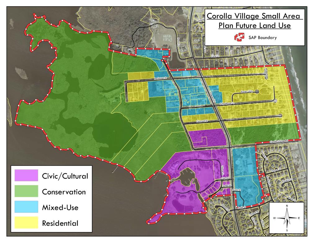
Mixed Use
Areas designated as mixed use are characterized by a diverse mix of land uses. This includes human scale commercial, residential, governmental, recreational, and civic uses. In general, mixed use areas support and emphasize pedestrian-oriented that includes a diverse mix of land uses as well as cultural and educational opportunities. Compatibility among the mix of uses with the area’s scenic characteristics should be maintained through compact development patterns that preserve open space, mature specimen trees, important natural and physical environments and scenic view sheds to support a coastal village atmosphere. Activities in the mixed use designation are intended to be low impact by being designed with a residential look, feel, and scale. Greater flexibility should be given in this area to encourage innovative and creative design that results in high-quality development compatible with the environment and overall vision.
Residential
Areas designated as residential are intended for the development and support of existing and future low density residential uses. Commercial uses, with the exception of home occupations, are not encouraged in this area. These areas should be designed to reflect and enhance the coastal village feel by minimizing clearing and grading, limiting use of impervious surfaces, and encouraging structures that reflect coastal village architecture. Development in this designation should encourage and facilitate pedestrian movement safely to adjacent neighborhoods, mixed use areas, and civic/cultural destinations.
Civic/Cultural
The civic and cultural designation provides for the community’s public and non- profit facilities, parks and public spaces, and natural resources. The civic/cultural designation includes civic uses, public use facilities, government operation buildings, environmental and cultural destinations. These areas are intended to serve as gathering places, be easily accessible to the local residences through a variety of transportation alternatives, and should not be isolated from surrounding uses.
Conservation
The conservation designation offers protection to significant, limited, or irreplaceable sensitive areas. The conservation designation should be applied to wetlands, estuarine and coastal shoreline, estuarine waters, public trust waters, Significant Natural Heritage Areas (as designated by the State Natural Heritage Program), and other similar lands that are environmentally significant because of their natural role in the integrity of the coastal region (including but not limited to bottom land hardwoods, pocosins, and swamp forests containing significant productive, natural, scenic, cultural, or recreational resources). Conservation areas should be preserved and not developed. However, small areas of upland may be appropriate for limited development provided that work is performed in a very controlled, low impact manner through careful planning and cautious attention to the preservation of environmental features and a sustainable design approach that includes low impact development techniques. Appropriate limited development may include, passive and active recreational facilities such as trails and parks; eco-businesses dependant on water or other natural resource areas as a basis for operation; and governmental and community facilities provided that the footprint of development is minimized to preserve important ecological resources and view sheds. The provision of infrastructure and services should not stimulate or intensify development in these fragile areas. Proper management of these areas is needed to conserve the natural, cultural, recreational, scenic or biologically productive value of these areas.