Currituck County declared a local State of Emergency and ordered a mandatory evacuation for the Off-Road Area of Corolla, effective at 9:00 am on Wednesday, August 20, 2025. Anyone who may need evacuation assistance may contact Currituck County Emergency Management at 252-232-2115.
The beach strand driving area will receive significant storm surge today, especially during periods of high tide. Citizens should avoid visiting the beach today.
Double Red Flags are posted on all beaches in Currituck County on Thursday, August 21. Water entry is prohibited.
The Carova Beach Convenience Center will be closed on Thursday, August 21.
Due to predicted impacts from Hurricane Erin, the regularly-scheduled Friday trash collection in Corolla (August 22) will be postponed until Monday, August 25. At this time, all other trash collections remain as scheduled and the convenience centers remain open for public use.
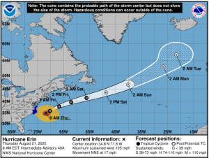
August 21 updates from the National Weather Service:
-
- Large, building waves, coastal flooding, and dangerous surf zone conditions will continue along the Mid-Atlantic coast for the rest of the week. Coastal conditions will continue to deteriorate today. Significant beach and dune erosion is likely. While Erin will track well offshore of the area from now-Friday, it is a large storm and impacts will be felt far outside the cone.
- A Tropical Storm Warning remains in effect for Currituck County, VA Beach, the VA Eastern Shore, all of the Atlantic Coastal waters, Chesapeake Bay, and Lower James River.
- Coastal Flood Warnings remain in effect for today/Friday for the Atlantic coast of Maryland, Virginia and NE North Carolina, in addition to the Chesapeake Bay south of the York River. Major flooding is possible in areas adjacent to the Lower Bay, VA Beach, and the Atlantic coast of Currituck County during this evening’s high tide cycle. This corresponds to inundation of 1 to 3 feet above ground level in vulnerable areas.
- There is a HIGH rip current risk through at least part of the weekend. Very dangerous swimming and surfing conditions are expected. In addition, wave action will likely result in significant dune/beach erosion through Thursday night.
- Marine Weather – Tropical storm force wind gusts will likely continue through this evening. Dangerous seas of 12-17 feet are forecast by this afternoon.